|
|
Blogroll
|
|
Most recent articles |
|
Highlights |
|
States and Economies |
|
World economies: 15 of 50 largest economies are U.S. States: |
|
World States – Table 1 |
|
History and Society |
|
Fourth of July aboard the W.W. II aircraft carrier the U.S.S. Hornet |
|
A. L. Kroeber's The Civilization of California's Far Northwest |
|
The Arab Admiralty – and an Arab naval view of the Crusades |
|
Excerpt from “The Wife of Bath's Prologue” by Geoffrey Chaucer |
|
“Horsey” Vikings: exploring origin of the “Rohirrim” in The Lord of the Rings
|
|
The Battle of Crécy by Winston S. Churchill |
|
Monotheistic Paganism, or just what was it Christianity fought and faced? |
|
Medieval constipation advice for travelers: “A ripe turd is an unbearable burden” |
|
Alexis de Tocqueville's bicentennial: Anticipatory censorship in colonial America |
|
Antiquity vs. Modernity: Alexis de Tocqueville on the mind of the slaveholder vs. soul of America |
|
Federalism, and Alexis de Tocqueville on the origins of American democracy |
|
Science, Technology, Space |
|
Looking in the right direction – towards the future – with regard to global warming |
|
Know Your Neighborhood: from Andromeda to Fermions and Bosons |
|
Magnetars and Pulsars: Science's special section on pulsars |
|
The Geneva-Copenhagen Survey of Sun-like Stars in the Milky Way |
|
Galactic Central: the Black Hole at the Center of the Galaxy |
|
Politics and War |
|
America’s strong arm, wielding the Sword of Iraq, slays the multi-headed Hydra of Al Qaeda |
|
Regional and Personal |
|
Tamara Lynn Scott |
What wailing wight
Calls the watchman of the night?
William Blake
Whirl is king
Aristophanes
“Jumping into hyperspace ain't like dustin' crops, boy.”
Han Solo, another galaxy
|
Blogroll |
|
Grand Central Station |
|
Legal and Economic |
|
History and Society |
|
Science, Technology, Space |
|
Politics and War |
|
Eclectic |
|
Regional |
|
Reciprocal |
© Copyright 2002 – 2009
Michael Edward McNeil
Impearls: Cartographic Vortices
Item page — this may be a chapter or subsection of a larger work. Click on link to access entire piece.
Earthdate 2004-05-19
| Cartographic Vortices |
|
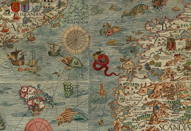
Earthdate 2004-05-06's issue of the journal Nature has a fascinating news item about the beautiful 1539 Scandinavia map created by Olaus Magnus, a Swedish priest, excerpted above. Click on this link for the complete map (courtesy James Ford Bell Library, University of Minnesota).
Magnus's map, as with many antique maps, is illuminated with sea monsters and fabulous beasts, while amongst them, on the sea to the east and south of Iceland, swirl seemingly decorative vortices. Now we learn that the eddies aren't decorative. Tom Rossby, an oceanographer at the University of Rhode Island, Kingston, first noticed the resemblances between the swirls on Magnus's map and thermal images from Earth observation satellites.
As the Nature piece notes: 1
The eddies are created where the Gulf Stream meets cold Arctic waters. […] Ancient mariners would have noticed these large-scale eddies, which pull on shipping vessels and have greener waters.
Accurate mariners' information must have made it to Magnus while he was composing the data for the map.
Reference
1
Nature,
Vol. 429, Issue No. 6987 (Issue dated
Figure
f1
Olaus Magnus' Map of Scandinavia 1539,
courtesy University of Minnesota, James Ford Bell Library.
UPDATE: 2009-12-23 05:30 UT: Changed image host for the map to Flickr. Added caption.
Labels: eddies, Faroe Islands, Iceland, James Ford Bell Library, Olaus Magnus, Scandinavia, Tom Rossby, University of Minnesota, University of Rhode Island Kingston, vortices
| (Blank last screen) |
|
2002-11-03 2002-11-10 2002-11-17 2002-11-24 2002-12-01 2002-12-08 2002-12-15 2002-12-22 2002-12-29 2003-01-05 2003-01-12 2003-01-19 2003-01-26 2003-02-02 2003-02-16 2003-04-20 2003-04-27 2003-05-04 2003-05-11 2003-06-01 2003-06-15 2003-06-22 2003-06-29 2003-07-13 2003-07-20 2003-08-03 2003-08-10 2003-08-24 2003-08-31 2003-09-07 2003-09-28 2003-10-05 2003-10-26 2003-11-02 2003-11-16 2003-11-23 2003-11-30 2003-12-07 2003-12-14 2003-12-21 2003-12-28 2004-01-04 2004-01-11 2004-01-25 2004-02-01 2004-02-08 2004-02-29 2004-03-07 2004-03-14 2004-03-21 2004-03-28 2004-04-04 2004-04-11 2004-04-18 2004-04-25 2004-05-02 2004-05-16 2004-05-23 2004-05-30 2004-06-06 2004-06-13 2004-06-20 2004-07-11 2004-07-18 2004-07-25 2004-08-22 2004-09-05 2004-10-10 2005-06-12 2005-06-19 2005-06-26 2005-07-03 2005-07-10 2005-07-24 2005-08-07 2005-08-21 2005-08-28 2005-09-04 2005-09-11 2005-09-18 2005-10-02 2005-10-09 2005-10-16 2005-10-30 2005-11-06 2005-11-27 2006-04-02 2006-04-09 2006-07-02 2006-07-23 2006-07-30 2007-01-21 2007-02-04 2007-04-22 2007-05-13 2007-06-17 2007-09-09 2007-09-16 2007-09-23 2007-10-07 2007-10-21 2007-11-04 2009-06-28 2009-07-19 2009-08-23 2009-09-06 2009-09-20 2009-12-13 2011-03-27 2012-01-01 2012-02-05 2012-02-12


0 comments: (End) Post a Comment