|
|
Blogroll
|
|
Most recent articles |
|
Highlights |
|
States and Economies |
|
World economies: 15 of 50 largest economies are U.S. States: |
|
World States – Table 1 |
|
History and Society |
|
Fourth of July aboard the W.W. II aircraft carrier the U.S.S. Hornet |
|
A. L. Kroeber's The Civilization of California's Far Northwest |
|
The Arab Admiralty – and an Arab naval view of the Crusades |
|
Excerpt from “The Wife of Bath's Prologue” by Geoffrey Chaucer |
|
“Horsey” Vikings: exploring origin of the “Rohirrim” in The Lord of the Rings
|
|
The Battle of Crécy by Winston S. Churchill |
|
Monotheistic Paganism, or just what was it Christianity fought and faced? |
|
Medieval constipation advice for travelers: “A ripe turd is an unbearable burden” |
|
Alexis de Tocqueville's bicentennial: Anticipatory censorship in colonial America |
|
Antiquity vs. Modernity: Alexis de Tocqueville on the mind of the slaveholder vs. soul of America |
|
Federalism, and Alexis de Tocqueville on the origins of American democracy |
|
Science, Technology, Space |
|
Looking in the right direction – towards the future – with regard to global warming |
|
Know Your Neighborhood: from Andromeda to Fermions and Bosons |
|
Magnetars and Pulsars: Science's special section on pulsars |
|
The Geneva-Copenhagen Survey of Sun-like Stars in the Milky Way |
|
Galactic Central: the Black Hole at the Center of the Galaxy |
|
Politics and War |
|
America’s strong arm, wielding the Sword of Iraq, slays the multi-headed Hydra of Al Qaeda |
|
Regional and Personal |
|
Tamara Lynn Scott |
What wailing wight
Calls the watchman of the night?
William Blake
Whirl is king
Aristophanes
“Jumping into hyperspace ain't like dustin' crops, boy.”
Han Solo, another galaxy
|
Blogroll |
|
Grand Central Station |
|
Legal and Economic |
|
History and Society |
|
Science, Technology, Space |
|
Politics and War |
|
Eclectic |
|
Regional |
|
Reciprocal |
© Copyright 2002 – 2009
Michael Edward McNeil
Impearls: Northwestern California and the Klamath Mountains
Item page — this may be a chapter or subsection of a larger work. Click on link to access entire piece.
Earthdate 2004-06-07
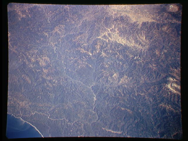
Orbital photograph of the Klamath Mountains region of the far northwest of California, Space Shuttle image
STS068-168-4A.
North is to upper left.
 Easily visible on the photo is the winding channel of the Klamath (California's third largest river, after the Colorado and Sacramento), entering the state across the top of the image from Oregon, disgorging into the Pacific at lower left.
Near the bottom of the photo, where the river can be seen to make a sharp right-hand bend, occurs its confluence with its largest tributary, the Trinity River, which comes in from lower-right, where the broad buff-colored Hoopa Valley can be readily seen.
Somewhat below the center of the image can be seen a broad ‘X’ in the Klamath, where the remote and exquisite Salmon River flows in from the southeast, while another stream, Wooley Creek, enters from the northeast.
The wild and scenic forks of the Salmon are accessible only through a pair of roads (one per fork) which, though paved, are single-lane only (and I don't mean one lane in each direction) for mile after mile.
The ranges through which the Salmon's forks run are known as the Salmon Mountains.
Beyond those, extending off the far right of the image can be seen the breathtaking Trinity Alps, shining whitely with lingering snow.
Back to the ‘X’, across the Klamath from the mouth of the Salmon, on a bluff overlooking a rapids adjoining an isolated little peak, stands the center of the world, known as Katimin, to the native Karuk. We'll have much more to say in the future about the Karuk and other peoples of the lower Klamath and Trinity rivers' remarkable civilization. On that same side (the right bank) of the river arise the rugged Siskiyou Mountains, and similar-named Wilderness, which sweep north and then, together with the river, turn east, forming a rampart barring the Oregon frontier. Across that border, along the left-top of the image, can be seen the Applegate River (a tributary of the Rogue) region of southwestern Oregon.
The fourth leg of the Salmon-Klamath rivers' ‘X’ (extending directly away from the viewer looking down from the space shuttle) is Wooley Creek, flowing out of the heart of the Marble Mountains (and the Marble Mountain Wilderness) located in the geometric center of the image. Trail book author Art Bernstein describes the Marble Valley, high up in those mountains, as “point blank: the Marble Valley may be the most beautiful place I've ever been. I consider it the ultimate journey into the glacial valleys of the Klamath Mountains system.” 1
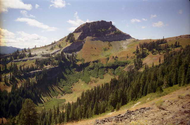
Beyond and to the east (upper right) of the Marbles in the space shuttle shot lies the buff-colored Scott Valley, an agricultural Shangri-la surrounded by towering mountains (with a few “island” mountains “floating” within the flat valley). Beyond yet more mountains, can be seen (stretching across the top mid-right of the shuttle photo) the (also tan-colored) Shasta Valley.
With that we depart the geologic domain of the Klamath Mountains and enter the ultra-volcanic realm of the Cascades. The Cascade Range stretches inland from the Pacific Coast all the way from California's Mount Lassen into British Columbia, including such great peaks as Mount Hood and Mount Rainier. In the space shuttle photo above, however, at the extreme upper right can be seen the white gleam of glaciers on the mightiest “stratovolcano” of them all, 14,162-ft. (4,316 meter) Mount Shasta, largest in bulk (some 350 km3 or 84 cu.mi.) and tallest (above its base) of the huge “stratocones” of the Cascades, together with serving as northern California's highest peak.

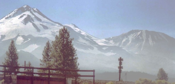
For a perspective on the tremendous difference geologically between the Klamaths and the Cascades, consider the distinction in ages: Mount Shasta, in its latest incarnation, is approximately 100,000 years old — or only about the age of our own species. The mountains of the Klamaths, contrariwise, are over 100 million years old — a factor of a thousandfold older.
It's not quite visible over the top edge of the space shuttle photo above, but the Klamath River bears another distinction: It slices completely across the Cascade Range, from its origin on the other side of the Cascades in the Klamath Falls region of southern Oregon. It's difficult for rivers (even if they pre-existed the volcanism) to cut or maintain their flow across a volcanic mountain range. Lava flows repeatedly fill incipient valleys and turn flowing waters back away from the smoking mountains. Only three rivers have managed to penetrate long-term the barrier of the high Cascades in North America: the mighty Columbia River of Washington, Oregon, and British Columbia; California's Sacramento River, via its longest tributary, the Pit River, originating (originally) at Goose Lake on the Oregon border in the extreme northeast of the state; and lastly the Klamath River.
The only major highways which run through the area pictured from space above are U.S. Route 101, proceeding up and down the coast in these parts, and (the most important route) Interstate-5, which follows the Shasta Valley just this side of Mount Shasta (passing almost under Shasta's pair of gigantic stratocones: an extraordinary sight when not totally socked in by weather). Thus, it's easily possible (as I myself managed, to my ultimate chagrin) to drive repeatedly from California to Oregon, back and forth up both roads over quite a number of years, without ever realizing there's this vast, complex, and magnificent formation of mountains, the Klamath Mountains, lying smack in between! The Klamath Mountains are remote and neglected even by Californians, since when natives think of going to the mountains, they typically think of the Sierras, while if the idea of the far north of California enters into their cognition, they then usually think of Mount Shasta.
Impearls is a California institution, located amongst the southernmost of the redwood forests in the Santa Cruz Mountains, some 80 miles (130 km) south of San Francisco, perched along the northern shore of half-moon shaped Monterey Bay. It's a beautiful, mild-climated region that we have had occasion to note attractions of on at least one occasion in the past. Impearls will continue to feature articles on regional issues, whether that “region” be central and northern California, the West of the United States, North America, the crust of the Earth, Inner Solar System, Milky Way, or Local Group of Galaxies.
One of the amusing things about living on the periphery of the San Francisco Bay Area, though, is the way the people of San Francisco and the Bay Area regard themselves as the epitome of “Northern California.” Yet California is such a huge, long drawn-out state (over 800 miles, or more than 1,300 km, from end to end), that up near the Oregon border in California one finds oneself actually closer to Portland (all the way on the opposite side of Oregon) than to the San Francisco Bay Area, much less the remainder of California.
The author of our favorite trail guide — Art Bernstein's Best Day Hikes of the California Northwest — describes the far northwest of California thusly: 2
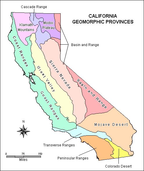
Three distinct geological provinces are represented in this book. Most spectacular are the Cascade Mountains, capped by 14,161 foot Mt. Shasta, Northern California's highest peak.
While the Cascades stretch from California's Mt. Lassen to British Columbia's Mt. Garibaldi, this book only nicks a corner of them. The range is characterized by extremely young volcanic peaks. Outpourings of lava and ash cover the landscape. Lassen National Park and Lava Beds National Monument superbly interpret the range's California portion.
The Klamath Mountains rank as northern California's oldest, remotest and most rugged. They consist of an immense granite intrusion, formed in the age of dinosaurs, probably as part of the Sierra. Other important Klamath rocks include an ancient, metamorphosed lava known as greenstone, plus various schists and marbles.
The Klamaths' jumbled cluster of jagged peaks, topping out at over 9000 feet, are dotted with hundreds of exquisite alpine lakes. Renowned for their beauty, the Klamaths include such ranges as the Trinity Alps, Marble Mountains, Siskiyous and North Yolla Bollys. They do not include the South Yolla Bollys.
Technically, the system does not quite extend to the coast. Detached segments, however, floating atop the younger Coast Ranges, bump the coast between Coos Bay, Oregon and Eureka.
Northwest California's dominant system is the Coast Range, also called the Mendocino Mountains. Geologically, it is known as the Franciscan Formation, a region of steeply folded and faulted sandstone and other marine rocks. Extending from San Francisco Bay to Eureka, the range attains 8000 feet elevation at South Yolla Bolly and 7000 feet at Snow Mountain. Few summits exceed 4000 feet, however.
Unlike the Klamaths, the Coast Range forms a series of lineal ridges, cut by deep river valleys, parallel to the coast. The highest peaks line up along the system's eastern edge, rising sharply above the Sacramento Valley.
A couple of small, isolated volcanic regions, unrelated to the Cascades or Coast Range, are tucked inside the Franciscan Formation between Clear Lake and Napa. This book does not address Northern California's Great Valley or Modoc Plateau geological provinces.
Serpentine is a granitic rock lacking in calcium and rich in heavy metals. The Klamaths and the Coast Ranges contain more of this rock than any other section of the United States.
Both serpentine, and the closely related peridotite, are the basement rock of the ocean floor. On land, they appear as elongated dikes and sills parallel to the coast. Such formations are believed bulldozed from the sea by the advancing continental plate.
Douglas fir, ponderosa pine, madrone and other common species won't grow on serpentine or are stunted by it. Other species will, however, including Jeffrey pine, knobcone pine, western white pine, incense cedar, Baker cypress and Brewer spruce. Numerous endangered shrubs and wildflowers grow nowhere else.
Many northwest California peaks over 5000 feet elevation have experienced glaciation. Glaciers form when annual snowfall exceeds melt and ice starts oozing down the mountain. The only glaciers these days are on Shasta, plus a few tiny ones in the Trinity Alps. Gouged out scars from former glaciers abound, however.
Glaciers not only carve out round-bottomed valleys as they move downward, they also chisel sharply backward into the peak. This headward cutting creates cirque basins with steep, amphitheater headwalls rising above a bowl. Almost all the Klamath Mountains' hundreds of alpine lakes decorate glacial cirques.
UPDATE:
2005-12-10 14:30 UT:
Changed hosting of images, and updated some of them slightly.
Thanks to the Earth Sciences and Image Analysis Laboratory, NASA Johnson Space Center, for the
beautiful image
of the Klamath Mountains from the space shuttle.
Thanks also to the California Geological Survey's
California Geotour
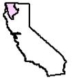
for the map of California's geologic provinces and the locator map to the Klamath Mountains province.
1
Art Bernstein, Best Day Hikes of the California Northwest, Mountain N'Air Book, 1991;
2
Art Bernstein, Best Day Hikes of the California Northwest, Mountain N'Air Book, 1991;
| (Blank last screen) |
|
2002-11-03 2002-11-10 2002-11-17 2002-11-24 2002-12-01 2002-12-08 2002-12-15 2002-12-22 2002-12-29 2003-01-05 2003-01-12 2003-01-19 2003-01-26 2003-02-02 2003-02-16 2003-04-20 2003-04-27 2003-05-04 2003-05-11 2003-06-01 2003-06-15 2003-06-22 2003-06-29 2003-07-13 2003-07-20 2003-08-03 2003-08-10 2003-08-24 2003-08-31 2003-09-07 2003-09-28 2003-10-05 2003-10-26 2003-11-02 2003-11-16 2003-11-23 2003-11-30 2003-12-07 2003-12-14 2003-12-21 2003-12-28 2004-01-04 2004-01-11 2004-01-25 2004-02-01 2004-02-08 2004-02-29 2004-03-07 2004-03-14 2004-03-21 2004-03-28 2004-04-04 2004-04-11 2004-04-18 2004-04-25 2004-05-02 2004-05-16 2004-05-23 2004-05-30 2004-06-06 2004-06-13 2004-06-20 2004-07-11 2004-07-18 2004-07-25 2004-08-22 2004-09-05 2004-10-10 2005-06-12 2005-06-19 2005-06-26 2005-07-03 2005-07-10 2005-07-24 2005-08-07 2005-08-21 2005-08-28 2005-09-04 2005-09-11 2005-09-18 2005-10-02 2005-10-09 2005-10-16 2005-10-30 2005-11-06 2005-11-27 2006-04-02 2006-04-09 2006-07-02 2006-07-23 2006-07-30 2007-01-21 2007-02-04 2007-04-22 2007-05-13 2007-06-17 2007-09-09 2007-09-16 2007-09-23 2007-10-07 2007-10-21 2007-11-04 2009-06-28 2009-07-19 2009-08-23 2009-09-06 2009-09-20 2009-12-13 2011-03-27 2012-01-01 2012-02-05 2012-02-12

0 comments: (End) Post a Comment