|
|
Blogroll
|
|
Most recent articles |
|
Highlights |
|
States and Economies |
|
World economies: 15 of 50 largest economies are U.S. States: |
|
World States – Table 1 |
|
History and Society |
|
Fourth of July aboard the W.W. II aircraft carrier the U.S.S. Hornet |
|
A. L. Kroeber's The Civilization of California's Far Northwest |
|
The Arab Admiralty – and an Arab naval view of the Crusades |
|
Excerpt from “The Wife of Bath's Prologue” by Geoffrey Chaucer |
|
“Horsey” Vikings: exploring origin of the “Rohirrim” in The Lord of the Rings
|
|
The Battle of Crécy by Winston S. Churchill |
|
Monotheistic Paganism, or just what was it Christianity fought and faced? |
|
Medieval constipation advice for travelers: “A ripe turd is an unbearable burden” |
|
Alexis de Tocqueville's bicentennial: Anticipatory censorship in colonial America |
|
Antiquity vs. Modernity: Alexis de Tocqueville on the mind of the slaveholder vs. soul of America |
|
Federalism, and Alexis de Tocqueville on the origins of American democracy |
|
Science, Technology, Space |
|
Looking in the right direction – towards the future – with regard to global warming |
|
Know Your Neighborhood: from Andromeda to Fermions and Bosons |
|
Magnetars and Pulsars: Science's special section on pulsars |
|
The Geneva-Copenhagen Survey of Sun-like Stars in the Milky Way |
|
Galactic Central: the Black Hole at the Center of the Galaxy |
|
Politics and War |
|
America’s strong arm, wielding the Sword of Iraq, slays the multi-headed Hydra of Al Qaeda |
|
Regional and Personal |
|
Tamara Lynn Scott |
What wailing wight
Calls the watchman of the night?
William Blake
Whirl is king
Aristophanes
“Jumping into hyperspace ain't like dustin' crops, boy.”
Han Solo, another galaxy
|
Blogroll |
|
Grand Central Station |
|
Legal and Economic |
|
History and Society |
|
Science, Technology, Space |
|
Politics and War |
|
Eclectic |
|
Regional |
|
Reciprocal |
© Copyright 2002 – 2009
Michael Edward McNeil
Impearls: HIC A.0: Afterview
Item page — this may be a chapter or subsection of a larger work. Click on link to access entire piece.
Earthdate 2005-11-12

|

|
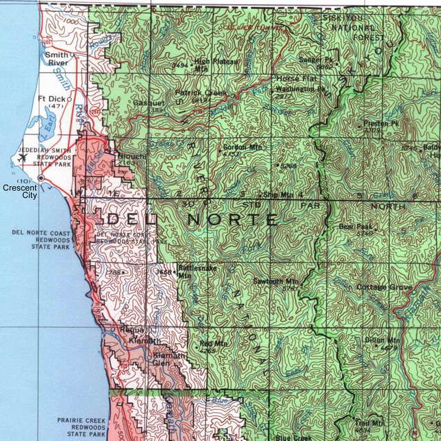
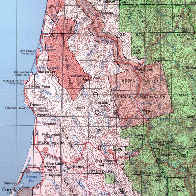
Figure B – State of California, North Half (excerpt of Northwest portion).
U.S. Geological Survey 1:500,000-scale state map series.
B
Legend to map
shown at half scale
(miles or km on legend are twice as far as on map)
The foregoing map reveals the modern territory, complete with contour lines, starting with the city of Eureka on the northwestern coast of California (a little north of Cape Mendocino and Punta Gorda at which points the coastline turns from trending generally northwestward toward north), all the way past the mouth of the Klamath, thence to beyond California's Crescent City, and on to the California-Oregon frontier.
What's changed since the above U.S. Geological Survey map was published is that since that time the Yurok Reservation has split off into a separate reservation from the Hoopa Valley Reservation. This means that the entirety of the indian reservation segment shown from Weitchpec at the confluence of the Klamath River and the Trinity, downriver on the Klamath to its mouth is now Yurok Reservation, and indeed the Yurok Indians are now officially the most populous tribe (approaching 5,000) in California today. Notice on the map the way the boundaries of what's now the Yurok Reservation follow the Klamath at about a mile's distance on both sides from the river. A mile on either side happens to be the same distance from the river per Kroeber's account as where private claims to the land ceased. (It's not clear that there's a connection there, mind you, but I find it quite fascinating.) Beyond the Yurok Reservation proper, the Coast Yurok have separate tribal existence in Trinidad Rancheria and Big Lagoon Rancheria shown on the map.
The green areas (excepting the other-green county-line boundary) are National Forest lands (still available for Indians to hunt and fish on, and visit, as Americans generally can do). Notice how much of the area is included in the rose-colored constellation of state and national parks — e.g., Redwood National Park and its lesser known kin. This area incorporates some the grandest, most stunningly imposing and splendid landscapes (or perhaps one should say forest-scapes) on the planet.
See the legend to the map here at half scale (miles or kilometers on the legend are twice as far as shown on the map).
| (Blank last screen) |
|
2002-11-03 2002-11-10 2002-11-17 2002-11-24 2002-12-01 2002-12-08 2002-12-15 2002-12-22 2002-12-29 2003-01-05 2003-01-12 2003-01-19 2003-01-26 2003-02-02 2003-02-16 2003-04-20 2003-04-27 2003-05-04 2003-05-11 2003-06-01 2003-06-15 2003-06-22 2003-06-29 2003-07-13 2003-07-20 2003-08-03 2003-08-10 2003-08-24 2003-08-31 2003-09-07 2003-09-28 2003-10-05 2003-10-26 2003-11-02 2003-11-16 2003-11-23 2003-11-30 2003-12-07 2003-12-14 2003-12-21 2003-12-28 2004-01-04 2004-01-11 2004-01-25 2004-02-01 2004-02-08 2004-02-29 2004-03-07 2004-03-14 2004-03-21 2004-03-28 2004-04-04 2004-04-11 2004-04-18 2004-04-25 2004-05-02 2004-05-16 2004-05-23 2004-05-30 2004-06-06 2004-06-13 2004-06-20 2004-07-11 2004-07-18 2004-07-25 2004-08-22 2004-09-05 2004-10-10 2005-06-12 2005-06-19 2005-06-26 2005-07-03 2005-07-10 2005-07-24 2005-08-07 2005-08-21 2005-08-28 2005-09-04 2005-09-11 2005-09-18 2005-10-02 2005-10-09 2005-10-16 2005-10-30 2005-11-06 2005-11-27 2006-04-02 2006-04-09 2006-07-02 2006-07-23 2006-07-30 2007-01-21 2007-02-04 2007-04-22 2007-05-13 2007-06-17 2007-09-09 2007-09-16 2007-09-23 2007-10-07 2007-10-21 2007-11-04 2009-06-28 2009-07-19 2009-08-23 2009-09-06 2009-09-20 2009-12-13 2011-03-27 2012-01-01 2012-02-05 2012-02-12

0 comments: (End) Post a Comment